Researching the Earth's magnetic field

Category: Fieldwork

Constraining reversal rates in the lower Carboniferous

We have a new visitor in our lab these days, plastering, drilling and cutting handsamples of limestone blocks. Tereza Kamenikova is a Masters by Research student, doing research at Lancaster University supervised by Dr. Mark Hounslow. She also studies for a second Master’s degree at Charles University in Prague (Czech Republic). The project she is working on in Prague is called ‘Cyclicity and sedimentation rate analysis of the oldest pro-delta deposits in the Most Basin’. During her bachelor degree, she worked on the nature of magnetic anomalies on the Moon, by studying the Apollo 15 samples of lunar rocks.

Tereza is now in the field in South Cumbria, with Mark Hounslow and Courtney Sprain, to obtain more samples of Carboniferous limestones. This project aims to constrain the geomagnetic polarity of the lower Carboniferous, in order to gain a better understanding of the behaviour of the geomagnetic field during this time. South Cumbria has good exposures of lower Carboniferous limestones in abandoned quarries, of which Tereza is taking handsamples. The Carboniferous limestones in this region have been quarried for centuries, and are used as building stones, decorative stones, or are crushed to become rubblestone.

There has been practically no scientific research on these rocks over the last two decades, and we are hoping that Tereza’s project will enthuse a new generation of scientists to study these outcrops.


IGCP 652 – Bremen

As this is my first post, I should probably give a small introduction of myself and the project that I am working on. I am Annique van der Boon, and I am working on establishing reversal rates during the Devonian and Carboniferous, within the context of the DEEP project.

Last month, I went to Bremen, to the first meeting of IGCP 652 – Reading geologic time in Paleozoic sedimentary rocks . The IGCP projects are UNESCO initiatives that gather participants from all over the world to study a certain topic. IGCP 652 brings together astrochronology, radiometric dating and biostratigraphy, in order to improve the timescale of the Paleozoic, focusing on the Ordovician to Devonian.

The meeting started with a short course on astronomical tuning. For three days we followed lectures about Milankovitch cycles and how they are expressed in sedimentary successions. We then learned to use Astrochron software , in which you can analyse records with geological data for astronomical forcing. During the last day, we got to work with our own data. I had two sets of data from different sections, one of which did not show any cyclicity in the field, which was confirmed by using Astrochron. The other one looked very cyclic in the field, and  this one showed a very good match with one of the Milankovitch cycles, so I was very excited, as I had not done this kind of analysis before.

After the course, my favourite part of the meeting started: we went to look at some outcrops! Over the course of three days, we saw a lot of amazing geology in the Rhenish Massif. We went to quarries that exposed Devonian sediments and volcanic rocks, Permian salts, and Triassic oolites and stromatolites. Especially the Effenberg quarry was impressive. I also made a short video to shows some of the outcrops and explain the IGCP 652 project, which you can see below.

The last part of the meeting consisted of many great talks and posters (mostly) about Paleozoic sedimentary rocks. It was great to meet so many people that also work on the Devonian, and we established a lot of new collaborations during the meeting.

I am interested to find more Devonian and Carboniferous sedimentary records to do magnetostratigraphy on. We are looking for sediments that possibly hold a primary Devonian and Carboniferous magnetisation, and  thus show low thermal maturity (indicated for example by conodont alteration index values of <3) and no signs of chemical alteration. If you happen to know any, please get in touch!

Famennian rocks in the Effenberg quarry showing cyclic sedimentation, picture taken by Anne-Christine Da Silva

The excluded island of Saint Helena

This January, Andy and I went to Saint Helena to collect rocks for my PhD. Just organising the trip there was already somewhat of an adventure. The airport just opened this October, and there had been some flights that had to return back to Africa because the wind was to strong to land on the cliff of the island called the Barn. Bringing our equipment on the plane is always a risk, but this time it was definitely not an option. The little plane that were to take us there would in no circumstance take our heavy drills and other tools. So we had to arrange a shipment and had to hurry with that too, since it would take over a month for the parcel to arrive on Saint Helena.

When the day finally came we flew to Johannesburg first. The plane to Saint Helena only goes once every week, so to avoid a delay of 7 days we decided to take 24 hours between the arrival in Joburg and the departure to Saint Helena. We had a nice hotel with pool, where Andy was working and I was enjoying the Sun (which we wouldn’t see much of in Saint Helena so I was happy I at least had some vitamin take-in). After a visit to the Apartheid museum and a nice meal in town, we were ready to get on the scary little plane the next day. After a stop in Windhoek we arrived on the magical island of Saint Helena. Literally in the middle of nowhere. Andy almost had a hart attack before we landed because he was sure we would fly into the cliff instead of land on it, but luckily everything went very smooth and soon we were in our little bungalow on top of the Ladder Hill. Ladder Hill road is a road that takes you all the way down to town, and where if you are there at the wrong time and you want to go down, you will be stuck for at least 30 minutes, since you have to give way to the traffic driving uphill.


The first few days we were mainly exploring the island and trying to get permission to drill wherever we wanted. They had warned us that drilling on Ladder Hill would probably not be permitted because of the rockfall and avalanche risk. Luckily the Rock Guards not only gave us permission within seconds of meeting us, but they also decided to stay with us the entire trip, which gave us a lot more possibilities of drilling far away from where the car could get, since they could carry A LOT of weight. Besides these lovely islanders (one of which had never been off of Saint Helena), we also had help from our field assistant Dave, who called himself the Bugman (everyone on Saint Helena has a nickname which even gets passed over through generations) because of his insane knowledge of every insect. A true walking encyclopedia. Dave was the person who helped us find our way on the island and even helped us with his Geology knowledge from a degree from years ago (which not only says something about Dave’s memory, but also about mine and Andy’s knowledge in geology).

In 2 weeks you can do a lot more sampling than I would have expected before hand. Things ran smoothly and although we had some problems with the drills, we managed to spend our time very efficiently. That also lead to us being absolutely exhausted after the first week and a half. In the start we were so ambitious, drilling from 8.30 or 9 to 19.00 everyday, that we manage to drill 26 sites at Ladder Hill in 4 days, and 10 sites in Bank’s Valley (an hour walk with all our equipment each day) in another 2 days. We continued drilling the beautiful dykes at Sandy Bay in the south of the island, where we did a beautiful hike to a non-existing set of flows. After this first week I saw the number of samplebags on the cupboard increasing and increasing, and slowly my fieldbook started to get full (and extremely valuable). The fear for having to measure these samples for the rest of my life started to increase each day, but we did not want to waste ANY time. So we kept going and ended up with 300 sample cores and 62 hand samples from 52 different sites. There were definitely some life threatening situations both in cars as in the field, but we made it in the end. And both Andy and me were quite happy with the results.

As a reward for working this hard, we treated ourselves to a nice dive/snorkeling session where Andy had another scare for his life when he got eye to eye with a huge devil ray. He was seriously debating trying to get to shore (with high waves splashing on high rocks) when he saw the diving group swim up to take pictures and realised it was probably fine. Happy like a little kid I came back, and was desperate to go again the next morning. Andy almost kissed the ground when we came back, but he had a great time too ;-).

After this amazing (or amazingly scary) experience we still had to pack all our rocks in the box that had to be send back to the U.K. I say all, but technically we should have probably not packed ALL the samples, seen as they are still not here and I have been back over a month. However we were too tired to realise this and very disciplined checked off every sample bag and handsample when packing it in the big box with the equipment.

The only thing left to do was get this big box in our car and down to the shipping containers. This, however simple it sounds, was definitely a difficult job. But we made it and the relaxing could finally begin. But who wants to relax when you can do a hike to the highest point on the island? Dave took us on a beautiful walk through the green areas of the middle of the island. Something completely different than the views that we had seen so far. The cliffs on the shore of the island combined with the immensely green hills land inwards gave such a beautiful and dramatic view that we almost didn’t want to go down. Luckily we did, or we would have missed a smash goodbye party with the rockguards and a lovely meal with loads of breadrolls.

We had an amazing fieldwork thanks to the help of the Saint Helena Government (specifically Sam and Isabel) and our help in the field from Dave the Bugman and the Rock guards. And of course thanks to Andy!

Hopefully the rocks will be here soon, and I can finally start some measurements.

Ô Canada!

This summer, Simon Lloyd’s and my PhD projects of researching Earth’s magnetic field of the Proterozoic started in the geomagnetic laboratory at University of Liverpool. After a month of literature review, our attention was fully caught by Canada, where (Neo-)Proterozoic dykes have been a focus of research for the last 30 years.  Therefore, the two of us, accompanied by Andy Biggin, immediately and figuratively set sails to Canada to kick-start the first phase of our projects.

Hoping to build on the foundation of Dr. Henry Halls’ studies of the Franklin- and Grenville-Dykes, our journey’s first stop had to be his lab at University of Toronto! While his studies focussed on determining the ancient field directions to gain knowledge about the palaeolocation of Laurentia, my research will deal mostly with palaeointensities of the Ediacaran period (635-541Ma). As part of the DEEP project, the goal of my project is to gain a better understanding of Earth’s interior by analysing the ancient field strength while dealing with conflicting data of palaeofield directions in the Ediacaran period.

After one or two detours due to slight inaccuracies of our group’s two navigators (who will remain anonymous at this point), we finally reached University of Toronto’s palaeomagnetism lab in the outskirts of the University’s campus. There, Henry awaited us with his treasure – drawers full of samples, floppy drives full of measurement data and an enormous amount of additional knowledge and kindly allowed us to use his samples and data for our projects. The picture below shows the main part of the lab with the most elegant magnetometer in the centre. Despite the samples being perfectly organised, sorting out samples that are expected to produce good palaeointensity results took nearly a full day. But it was well worth the effort, as we ended up with over 100 cylinder specimens from 16 sites of the Grenville dykes for my project and about the same amount of specimens for Simon’s project.

In addition to the Grenville dyke samples, a second study area consisting of Ediacaran volcanic rocks of Newfoundland’s west coast will be used in my study as well. The directions of these rocks have been studied by Dr. Phil McCausland and Dr. Joe Hodych in 1998. Samples from 10 sites of the so-called Skinner Cove volcanics are currently being mailed from Memorial University of Newfoundland to our lab in Liverpool for intensity measurements.

As Toronto, Canada’s largest city, is always worth a visit, we concluded this first part of our Canada-adventure by strolling around the waterfront and taking a peek into downtown. It was great to see the lovely skyline and the CN Tower (shown in the picture below) while every other person was dressed in blue, thanks to a home game of the Toronto Blue Jays.

At this point we would like to express our gratitude to Henry Halls, Phil McCausland and Joe Hodych for their help and contributions to get us started in our projects. Now, back in the lab, we have started the first measurements and are excited to uncover the rocks’ last secrets.

Fieldwork in Canada!

It’s that chance for a Palaeomagnetist to get from behind the desk and into, perhaps, a part of the world they have not seen before. It’s a chance to see the ancient rocks in their natural environment and the opportunity to be at the very start of project at the data collection stage; the results of which will hopefully provide brand new information to the scientific community and indeed the world.

Why Canada?

This is part of a DEEP PhD project, in which we are trying to determine the strength of Earth’s ancient magnetic field at a time between 500 and 1000 million years ago. The first stage involves collecting rock samples from igneous events which occurred during this time period, many of which can be found in Canada.

The field trip concentrated on two small igneous plutons which were emplaced at around 530 million years ago, located in Chatham-Grenville and Mont Rigaud respectively. Within each area, we took samples from several sites (up to ten) in order to obtain a wide spread of samples, with GPS locations taken at  each of the sites as standard.

Later on, back at the laboratory, we will carry out palaeointensity analysis on the samples. The amount of magnetisation trapped in the rock is almost linearly related to the ancient magnetic field strength; because of this relationship, we are able obtain estimates for the strength of the ancient field.

A previous study had been carried out by Dr Phil McCausland in 2002 who, amongst other things, was interested in the ancient direction of the field. Where possible, we concentrated our efforts at known locations which gave good palaeodirection results. This was not easy because much had changed in the

When collecting samples, there are a number of considerations;

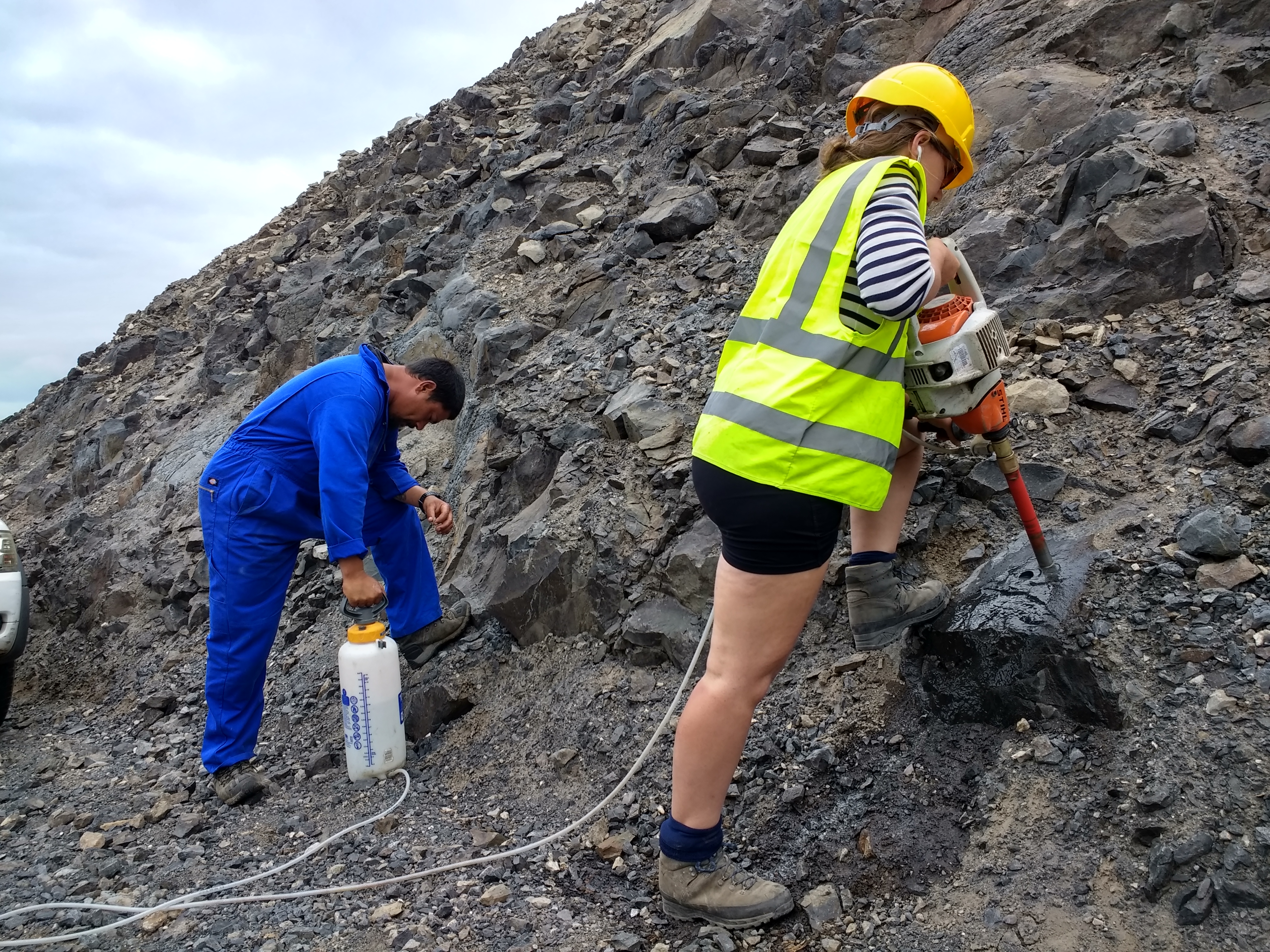
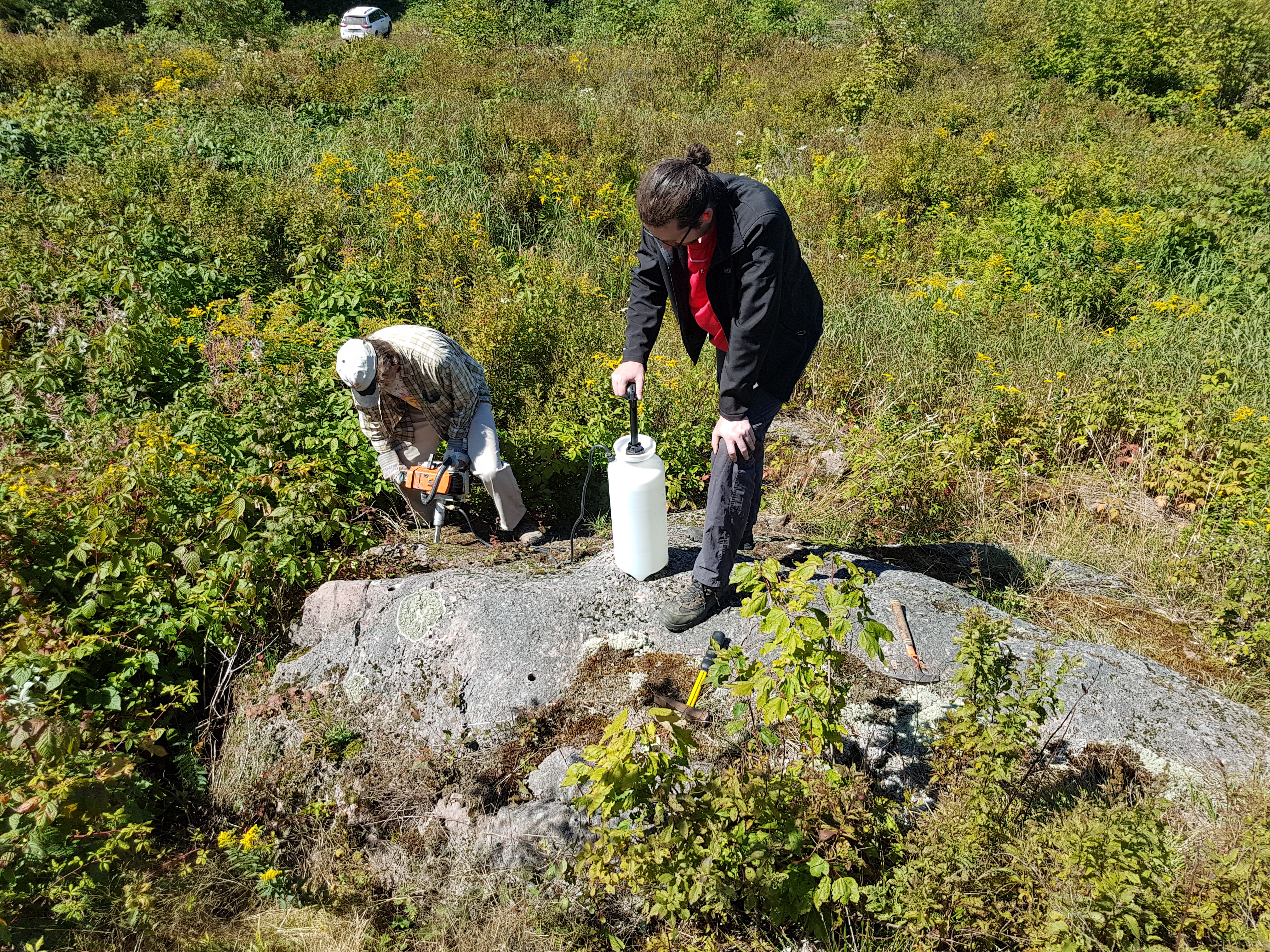
1) Because the remanence is only locked in to the rock as the rock cools below a certain temperature, the rock sample must also be kept cool whilst drilling it from the rock. The image below shows Phil McCausland drilling a sample from an outcrop whilst Daniele Thallner pumps water through the drill and out of the end to keep the sample cool.

2) The rock sample must be precisely orientated in x y and z, so that we can reproduce the orientation of the rock in the laboratory. This orientated reference frame is crucial if we want to determine the direction of the ancient geomagnetic field.

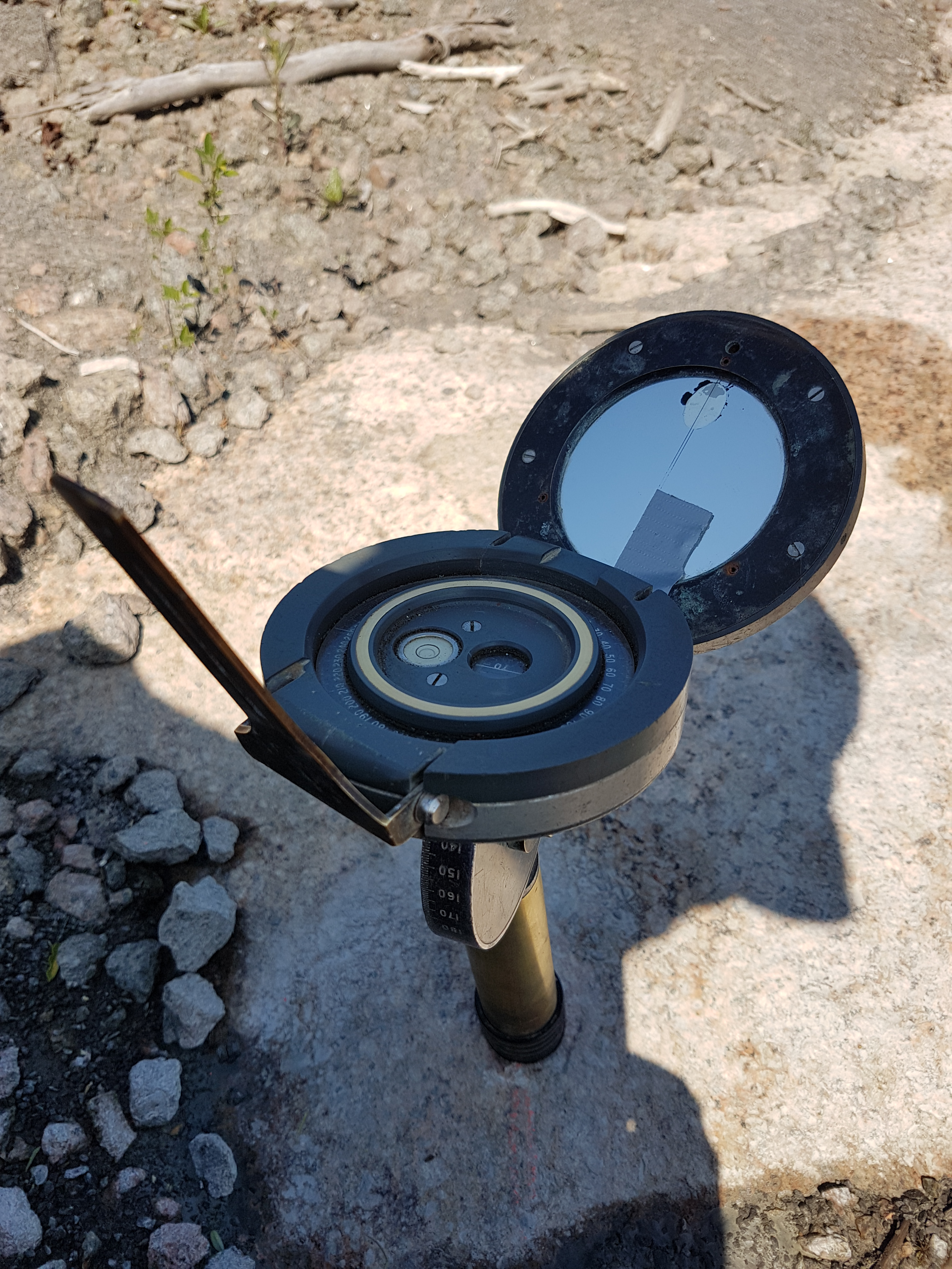
Below is an image of the sun compass used by the Liverpool Geomagnetism team. This is used to orientate the sample more accurately than using a magnetic compass with it’s associated errors (the compass needle can be deflected by the magnetic material within the rock when trying to measure).

The compass gets inserted and secured in place around the drilled core sample. First job is to make sure the spirit level bubble is centred. The compass only tilts forward and back so it must be rotated during this process; as a result, it is able to determine true inclination of the core sample. Because the bubble is centred, the compass is level in both x and y.

We take a sun sighting by turning the sun compass so that the sun casts a shadow though a small hole on to the fine line on the mirror, we then take a reading and record the time; this information is then put through some software to determine the X axis reading for the core sample. To obtain the Y axis reading, we simply add 90 degrees.

A magnetic compass reading of the X axis is also taken for comparison; this is achieved by aligning the sun compass with the dip direction of the core and placing a magnetic compass against the axis of the mirror.

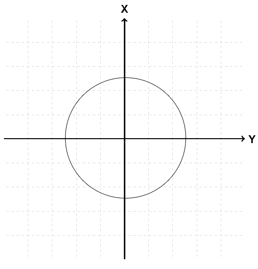
The image below shows the X and Y axes over a plan view of the core sample/ specimen. Both are measured as east of North, or in other words as the angular distance from North in a clockwise direction.

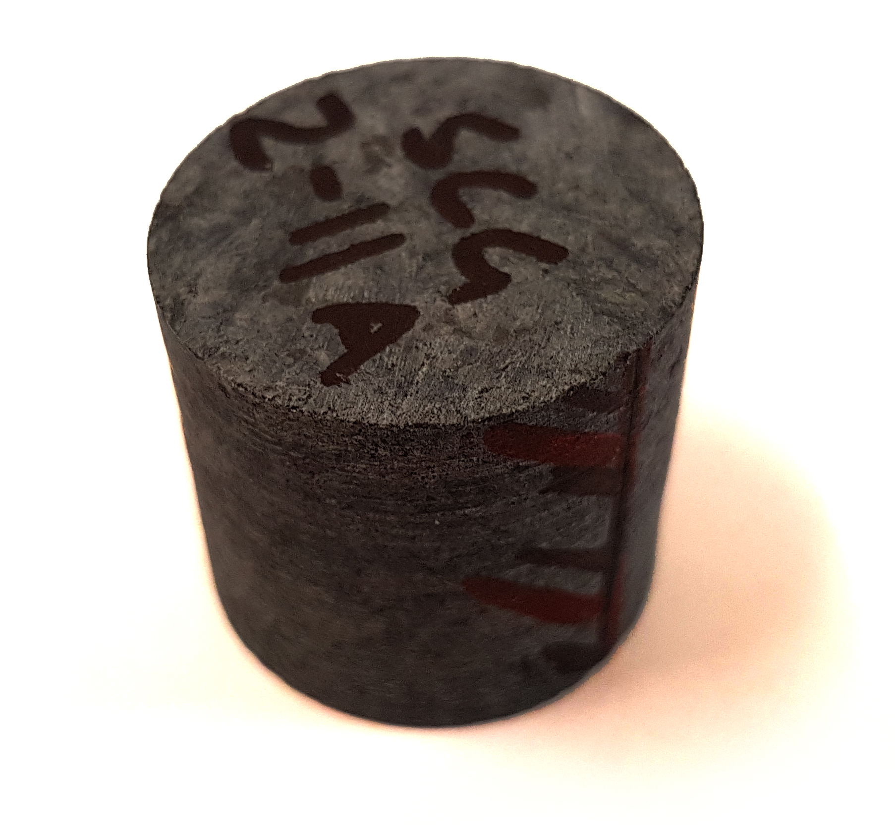
A standard 1” core specimen is shown (above right) with the ‘z’ axis and direction marked on the side of the specimen. This has been cut from a core, and depending how deep we drilled, we might expect to get ~3 specimens per core.

This specific core is marked as SCG2-11A

SCG is the name of the area which includes several sites

2 is the designated site number

11 is the core number

A is the specimen designation from this core, followed by B etc.

From Chatham-Grenville, a total of 138 standard 1” core specimens were produced from 7 different sites, plus some hand samples from a further site will produce more specimens.

A total of 35 Hand samples from 10 different sites were collected from Mont Rigaud; these can be orientated, drilled and cut in the laboratory, albeit with slightly less accuracy, to produce several core from each hand sample, which are then divided into specimens.


From Russia with Rocks (and a suitcase full of prezzies…)

IMAG0432I have just returned from my first trip to Russia and the Moscow and Borok Labs. There was originally supposed to be fieldwork in southern Siberia this Summer: sampling rocks with the hope they would tell us about the Earth’s magnetic field 400 million years ago. However, a few months back, we discovered that many of the targeted sections have already been studied by the Moscow group. The head of that lab – Vladimir Pavlov – invited me to visit to discuss the work and I gratefully accepted in lieu of the fieldwork. The decision to cancel the sampling trip seems to have been a good one – Vladimir’s colleague Andrey Shatsillo had been there numerous times already and had a stack of data to show me and a sack of samples for me to return with. He also provided samples from some very intriguing sills of a similar age that gave good directions but which were highly anomalous. Vladimir and Andrey shared their opinion that the magnetic field was in a very strange state at this time – an intriguing hypothesis ripe for testing with the equipment at Liverpool and Borok.

IMAG0399

Tatyana and Valera in front of Moscow State University where they both graduated from.

In addition to discussing science in Moscow, I enjoyed a Georgian meal with Vladimir and a sightseeing tour given by Tatyana Gendler of the institute. I also gave a seminar in their grand lecture theatre which was translated, slide-by-slide, by Valera Shcherbakov, a rather famous scientist in our area who had come down from his lab in the town of Borok, 350 km to the north. After some sightseeing in Moscow, I accompanied Valera on an overnight train to Borok and spent the remaining 2 days of my trip there. In comparison to cosmopolitan Moscow, Borok and surrounding area felt like the Real Russia. Borok itself has only 2,000 inhabitants but a fascinating history as the only privately owned piece of land in communist Russia. The owner was rather qualified for this honour, a nobleman’s son who had endured 28 years of jail as a communist revolutionary under tsarist rule. In prison, he had developed an interest in the sciences. He founded a biological institute in Borok and other research centres, including a geomagnetic observatory, followed in the ensuing years. Valera and his wife Valentina have been doing research at the palaeomagnetic lab at Borok for 40 years and their group continues to be one of the most prolific in the world.

The Shcherbakov(a)'s

Valera and Valentina Shcherbakov(a)

I had never met Valentina Shcherbakova before but had read many of her papers. She had already measured samples from Devonian collections that I was interested in so we pooled data and discussed a further measurement plan. She provided me with still more samples so that we can compare data obtained using the different methods in place at Liverpool and Borok. Valentina and Valera were also extremely kind in showing me the local area and giving gifts. I told them about my wife’s wish that I return with a book of classic Russian literature (in Cyrillic script). I left with five including two children’s books for my son. Not only this, Valentina handed me a beautiful patchwork quilt she had made herself to give to Brigid. Overall, it was a wonderful trip and it was fortunate that I had arrived with my suitcase only half full!

Fieldwork in New Zealand

Yes, I know it’s a hard life but somebody has to do it……

Meet the team


Left to right, Dr. Gillian Turner and PhD student Annika Greve from Victoria University, Wellington, New Zealand. Dr. Andreas Nilsson post doc and Emma Hodgson PhD student from University of Liverpool.

My PhD project ‘Further advances in determination of past geomagnetic field strength using synthetic samples, single crystals and basalt samples from the SW Pacific’ is part of a larger targeted palaeomagnetic study of the SW Pacific with Dr. Andreas Nilsson, post doc and supervisors Dr Mimi Hill and Dr. Andy Biggin  all at the University of Liverpool. We are lucky enough to be working with Dr. Gillian Turner and her PhD student Annika Greve at Victoria University, Wellington, New Zealand who are also gathering Southern hemisphere palaeomagnetic data. They are looking to complete a palaeosecular variation curve (changes in the direction of the local geomagnetic field) for the last 10,000 years in the SW Pacific area this can then be used as a reference curve to help dating in the area. At Liverpool we look at the past intensity of the magnetic field, the methods used and modelling of the data. These projects are filling gaps in Southern hemisphere palaeomagnetic data which will in turn increase the resolution of the models and our understanding of magnetic field behaviour. A big thank you to Gillian and Annika for what must have been an awful lot of time and effort in planning.


On top of Red Crater looking down into Central Crater, the darker area on the left is the 1955 flow we sampled

In February this year we headed off to the Tongariro National Park, central North Island to collect rock cores from lava flows on the flanks of Mount Ruapehu and Tongariro. We stayed at Whakapapa village on the slopes of Mount Ruapehu, a campsite for visitors who come for the spectacular walks and skiing this area is famous for. It was an ideal location for access to Ruapehu, Tongariro and the imposing Ngauruhoe (Mount Doom to any Lord of the Rings fans).

Our biggest issues in collecting samples were identifying suitable dated lavas and accessibility.

Finding lava was not a problem but finding flows that had been dated was! The younger Holocene lavas (less than ~11,500 years old) we were collecting are notoriously difficult to date with the commonly used potassium-argon (K/Ar) radiometric dating method. So far it has only been possible to date these lava flows through bracketing by tephra (ash) layers from past eruptions with known ages. Fortunately a group of geochemists from Victoria University, Wellington, NZ were using a new method of K/Ar dating to date Holocene flows as part of a mapping project in the area. They identified flows they had already dated using this method and some they were in the process of dating.

We were aware there would be accessibility problems and a degree of hiking or ‘tramping’ as it’s known in New Zealand would be called for we weren’t disappointed! Most locations were remote and required a 2-3 hour tramp to reach the flow we wanted. Despite the effort of carrying pack, drill and sometimes large quantities of water (to cool the drill bit) the further we walked the more spectacular the views became. A five hour climb up onto the Tongariro plateau then over Red Crater into Central Crater with equipment and 20 litres of water between three of us certainly was one to remember. Accessibility was also hampered by the ongoing threat of eruption in the area the most recent from neighbouring Te Maari vents in Nov 2012.

The area was dominated by dense andesites andsome basalt which proved to be quite taxing for the rock drills which were custom made from chainsaws with diamond tip drill bit attachments. The cores were 2.5cm diameter and around 10cm long these can then be shortened to fit the various instruments used for their analyses. Orientating the cores in respect to north was done with a sun compass as most of these rocks were strongly magnetised and deflected the needle on a magnetic compass.

As we were in a National Park we had to be very conscious of our impact on the natural environment so efforts were made to conceal the holes made by the drill. A before and after picture of a drill site shows effort was made to reduce any impact.


All in all we had a very successful trip to New Zealand so now it’s back to the laboratory for the next few months where we will be carrying out rock magnetic investigations to ascertain the best methods to measure the palaeointensities. The results of the of this project and associated collaborations will lead to a more comprehensive understanding of the magnetic field behaviour over the last 10ka in the SW Pacific.

Gillian, Andreas, Annika and Emma having a bit of fun!


Project Links

Targeted Palaeomagnetic Study of the SW Pacific

http://pcwww.liv.ac.uk/~nilsson/index.html

 Welcome to our project website aimed at presenting and visualizing new palaeomagnetic research from 0-5Ma rocks and pottery from in and around the SW Pacific .

We are a research group based in the Geomagnetism laboratory, University of Liverpool with collaborators in New Zealand and Australia. The project will incorporate improved geomagnetic field models with data collected from the SW Pacific. At present most of the data comes from the Northern hemisphere and Hawaii, leaving a data deficit in the Southern hemisphere. Fieldwork in New Zealand will took place in February 2012, while other samples will be donated by collaborators.

In particular palaeointensity will be used in geomagnetic field models to better understand the deep Earth processes that create the magnetic field.

Unlocking the Secrets of the Geodynamo – the South West Pacific Key 

http://www.victoria.ac.nz/scps/research/research-groups/enviro-phys-geo/geomagnetism/projects


A trip to South Africa

One of the main parts of my Phd project is to collect the samples on which I am going to carry out  the bulk of my experiments. Whilst so far I have been very lucky to have had samples to work on, donated to me by a number of colleagues, the time came when I needed some samples to call my own. I also felt that reading about my field area in journals was interesting, but, as many geologists will confirm, you need to visit your study area (field area) to fully take ownership of your research project.

The Barberton Greenstone Belt - my field area.

 So, in May 2011, Andy Biggin and I embarked on an adventure to sample some of the oldest rocks in South Africa. We  traveled to Badplaas in the northeast of the country, which along with  the larger Barberton (to the north), serves as the gateway to the Barberton Greenstone Belt. At our accommodation, we met up with Prof. Marteen de Wit (AEON), who has been working in the area for over 30 years, and, as you can imagine, has become quite an expert in the geology of the belt.

 Prior to the trip, and as a result of work carried out by myself, but in most cases by others (Biggin et al 2011; Tarduno et al. 2007 & 2010; Usui et al. 2009; and Yoshihara & Hamano, 2004); Andy and I had identified areas that we wanted to target for sampling. The first order of business during the field work was to find places where we could reach the outcrop – which we would then drill. Palaeomagnetists can sometime be thought of as lazy when it comes to field work: in order to drill a locality we carry a large amount of equipment, so walking for kilometers to get to an outcrop is not really an option (unless the outcrop is truly unique!). Therefore, finding tracks to get to the outcrop became just as important as finding the outcrop itself. To that end, we spent the first few days, with Marteen as an excellent guide, hunting down the best spots for sample collecting.

One of our sampling sites.

 The reconnaissance was fun, exciting and sometimes a little challenging! I was the designated driver of our large 4×4, and not having driven off road prior to this trip, the first ford crossings, steep uphill climbs and U-turns in VERY small tracks were interesting to say the least. Nevertheless, we found some excellent localities to sample, surrounded by beautiful scenery.

 Next, I had to get to grips with our drill and learning how to orient the samples we collected. Geomagnetic samples are, for the most part, collected with a portable drill with a water cooled corer, which is diamond tipped. The drill is used to obtain a rock core which should be roughly 10cm long, although this varies depending who drills the core and how good they are at drilling (we discovered that Andy is far better at this job than I am).

Andy Drilling with a little help to operate the water pump.

 Before removing the core from the outcrop, its orientation within the outcrop must be accurately measured. This is done by slipping an orientation device (we used a sun compass and magnetic compass) over the core and measuring the inclination (dip) of the core axis and then using the sun and magnetic compasses for determining the azimuth of the core axis (Butler, 1992). Making detailed notes of the geology and field relationships in my field notebook was another of my main tasks on the trip.

Andy, orienting cores in another of our spectacular localities.

The trip was a success; we collected a large amount of samples, which now means I have a lot of work at the lab carrying out experiments. Working in South Africa was filled with amazing experiences such as: knowing that about 100m downstream of where we were working, there was a family of hippos; or encountering black rhinos at the end of a very long day; or knowing that I was sitting on some of the oldest rocks in the world!!! In truth, this post could have filled many, many pages, as there are so many anecdotes that I could tell about a long, but very productive trip.

Hippo in the field area!!!

Powered by WordPress & Theme by Anders Norén